
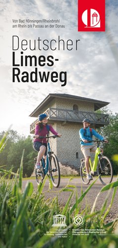
Explore the UNESCO World Heritage Site Limes by bike: The German Limes-Cycle-Path runs for more than 1100 kilometres past the important Roman stations along the Lower Germanic Limes, then along the Upper Germanic-Raetian Limes between the Rhine and the Danube and finally along the Danube Limes. Attractive towns lie along the way, as do renowned spa and recreation centres and picturesque villages.
Apart from the numerous Roman attractions, the scenic highlights alternate along the route: from the Lower Rhine, through the cities of Cologne and Bonn, from the Rhine-Westerwald Nature Park through the Lahn Valley, the Taunus, the Wetterau, the Main Valley, the Odenwald, Hohenlohe, the Swabian-Franconian Forest, the Swabian Alb, the Franconian Lake District, the Altmühl Valley Nature Park and along the Danube to Passau.
However, since the Romans had not yet thought of today's cyclists when they built the Limes, you can also expect some hilly sections that will challenge the cyclist's sporting ambition. The effort is then rewarded by the cultural diversity that the cycle path has to offer. And the entire route can also be divided into smaller sections and stopovers, as the towns have very good overnight accommodation and well-kept gastronomy to offer.


The German Limes Cycle Path follows the UNESCO World Heritage Limes and links numerous sights from the Roman era. Cyclists with an interest in history will find reconstructed Limes watchtowers, preserved and partially reconstructed forts, shelters over the ruins of Roman baths, fortifications with ramparts, moat and palisades and, of course, impressive museums.
The German Limes Cycle Path is signposted in various ways:
In some places, the signposting was done by inserts in the main signposts of the cycle routes. The aim of the route definition was to guide cyclists along the UNESCO World Heritage Site Limes on well-developed cycle paths and forest tracks.
The German Limes Cycle Path starts at the German-Dutch border near Kleve in North Rhine-Westphalia and follows the Rhine Cycle Route Euro Velo 15 along the Rhine. Along the route, you pass several towns with a Roman past, such as Xanten, Duisburg, Düsseldorf, Neuss, Cologne and Bonn, all the way to Remagen in Rhineland-Palatinate.
Below you will find this section divided into 5 daily stages. For each stage, in addition to information on the route, you will also find GPS tracks to download and a selection of accommodation along the way.
In this section, the German Limes Cycle Route follows the signposting "Rhine Cycle Route EuroVelo 15".


The German Limes Cycle Route begins at the German-Dutch border near Millingen on the Rhine in Kleve-Bimmen. The route then leads via Keeken to Düffelward. The cycle path continues via Wardhausen to Griethausen. Then you cross the Griethauser Altrhein.
Follow the cycle path to Emmericher Straße and cross the Rhine to Emmerich. You will then reach the Rhine promenade via Eltener Straße. From there, continue to the railway station and then leave Emmerich via Reeser Straße.
From here, the cycle path first leads to Vrasselt, Praest and Bienen. From there, first continue in the direction of Esserden and then finally cross the Rhine to Niedermörmter before Rees via the Rhine bridge "Rees-Kalkar". Via Obermörmter you then reach the Xanten district of Wardt, passing the Xanten North Sea.
In Xanten, you then continue along the South Lake and arrive at the Xanten Archaeological Park. On the site of the former Roman city of Colonia Ulpia Traiana, the LVR Archaeological Park Xanten invites you to an exciting excursion into history.
Leave Xanten at Bislicher Insel and finally cycle along the banks of the Rhine and the Rheinaue to Büderich.
The entire route of the German Limes Cycle Path available for download in all common file formats:
For a better overview, the route is also available divided into four sections. This allows you to plan your next trip or excursion to the unique UNESCO World Heritage Site Limes in the best possible way.
Our accommodation directory:
For a better overview, you can sort the accommodation alphabetically or by location along the Limes.
From Wesel-Büderich drive along the Rhine towards Wallach. Before Wallach, however, continue in the direction of Ossenberg and Orsoy along the Rhine foreland. In Orsoy, cross the town via Hafendamm, Egerstraße and Binsheimer Straße.
Continue via Viehsteig, Angewangtweg, Sardmannsbuchweg, Am Kirchweg and Giesenkirchweg to Baerl. Follow Binsheimer Straße and Hofstraße to the banks of the Rhine. Continue along the Rhine in the direction of Duisburg.
Follow Halener Straße through In den Haesen. The route continues via Husemann Straße, Imbuschstraße and the cycle path to Essensberg. In Essensberg you cycle under the motorway bridge and then past Werthauser Wardt. Finally, you reach the Bridge of Solidarity (Brücke der Solidarität).
The entire route of the German Limes Cycle Path available for download in all common file formats:
For a better overview, the route is also available divided into four sections. This allows you to plan your next trip or excursion to the unique UNESCO World Heritage Site Limes in the best possible way.
Our accommodation directory:
For a better overview, you can sort the accommodation alphabetically or by location along the Limes.
In Duisburg, cross the bridge of solidarity to change the bank of the Rhine. In Hochfeld, continue to the Rhine bridge approach and then via Rheinhauser Straße, Wörthstraße and Wanheimer Straße to Wanheimort.
The route continues via Obere Kaiserswerther Straße in the direction of Angershausen. Then in Angershausen take Steinbrinkstraße, Goetzkestraße and the cycle path along the Anger. From there you will reach Düsseldorfer Landstraße.
Follow Düsseldorfer Landstraße in the direction of Wittlaer and Kaiserswerth. Continue along Hubert-Eulenberg-Weg to the banks of the Rhine. The cycle path continues past Düsseldorf Airport in the direction of Stockum. Follow Kaiserswerther Straße to Reeser Platz station and then take Reeser Straße to the banks of the Rhine.
In Düsseldorf, you pass the old harbour and cycle along Schulstraße and Benrather Straße to Königsallee.
The entire route of the German Limes Cycle Path available for download in all common file formats:
For a better overview, the route is also available divided into four sections. This allows you to plan your next trip or excursion to the unique UNESCO World Heritage Site Limes in the best possible way.
Our accommodation directory:
For a better overview, you can sort the accommodation alphabetically or by location along the Limes.
In Düsseldorf, drive from Graf-Adolf-Platz into Talstraße. Continue via Bilker Allee, Weberstraße, Esmarchstraße, Heeresbachstraße, Karolingerplatz and Himmelsgeister Straße. Follow the cycle path past Wersten, Holthausen. In Benrath, cycle to the banks of the Rhine.
Then ride past Benrath Castle Park and on to Urdenbach. Then in the direction of Zons. And from Urdenbach to Zons, cross the river on the Rhine ferry. In Zons, first take Rheinstraße, then Schloßstraße and Wiesenstraße to Dormagen-Rheinfeld.
Pass the sewage plant and follow the Rhine bank and Neusser Landstraße to Worringen. Continue in the direction of Fühlingen; here you drive along Industriestraße to Fühlinger See. Then via Emdener Straße and Geestemunder Staße back to the banks of the Rhine.
The cycle path then continues via Niehl and the Niehler Hafenbrücker. Via the streets Am Molenkopf and Niederländer Ufer, the route then continues to Cologne to the Zoobrücke bridge.
The entire route of the German Limes Cycle Path available for download in all common file formats:
For a better overview, the route is also available divided into four sections. This allows you to plan your next trip or excursion to the unique UNESCO World Heritage Site Limes in the best possible way.
Our accommodation directory:
For a better overview, you can sort the accommodation alphabetically or by location along the Limes.
In Cologne, cross the Rhine at the Zoobrücke bridge. The route continues past the Rhine Park and along the Rhine. First you pass the Deutz swing bridge and then cycle through Alfred-Schütte-Allee and Weidenweg.
Along the river bank you will now reach Westhoven, Ensen, Porz and Zündorf. You then continue on to Längel and then Lülsdorf. Here you leave the banks of the Rhine and follow Bergstraße, Berliner Straße, Feldmühlstraße to Niederkassel and there Hauptstraße, Waldstraße, Rathausstraße and then along the Rhine again.
The cycle path continues via Rheidt to Mondorf. Then take the ferry to Bonn-Graurheindorf. First you continue along the banks of the Rhine, then via Karl-Legien-Straße and Werftstraße to Bonn-Castell. The cycle path continues along the Rheindorfer Bach stream and then leads along Kölner Straße to Chlodwigplatz.
The Kaiser-Karl-Ring then leads to Bonn's main railway station. Continue via Kaiserplatz, Kaiserstraße, Bundeskanzlerplatz, Willy-Brandt-Allee, Heussallee towards the banks of the Rhine. Follow the bank in the direction of Plittersdorf, Rüngsdorf and Mehlem.
Between Mehlem and Rolandswerth is the state border between North Rhine-Westphalia and Rhineland-Palatinate. The route also follows the banks of the Rhine in Rhineland-Palatinate. Via Rolandswerth, Rolandseck and Oberwinter, you finally reach Remagen.
The Roman Museum in Remagen displays finds from the period between the 1st century and the 5th century AD, such as gravestones, grave goods and objects of daily use like ceramics, jewellery and weapons. During a guided tour of the town, visitors can also admire the hypocaust heating system in the former Roman fort, which is otherwise not open to the public.
The entire route of the German Limes Cycle Path available for download in all common file formats:
For a better overview, the route is also available divided into four sections. This allows you to plan your next trip or excursion to the unique UNESCO World Heritage Site Limes in the best possible way.
Our accommodation directory:
For a better overview, you can sort the accommodation alphabetically or by location along the Limes.
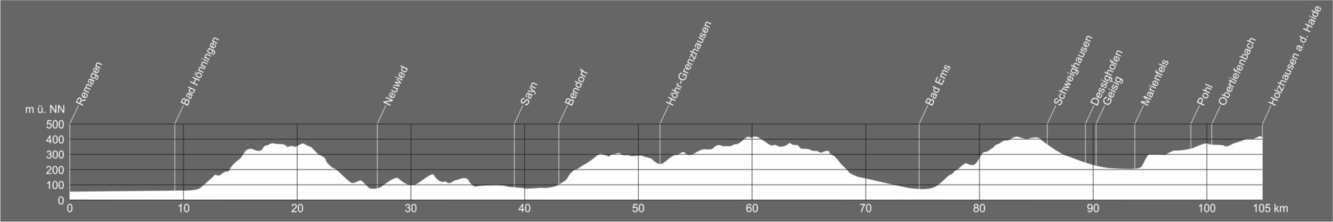
The German Limes Cycle Path initially continues to follow the Rhine Cycle Route EuroVelo 15. From Bad Hönningen, it follows the brown signs with the Limes Tower. It leads through beautiful, unspoilt low mountain landscapes and follows in the direct footsteps of the Romans. From the Rhine plain, the trail climbs into the front Westerwald. Via Neuwied, Bendorf and the Kannenbäckerland, you reach the spa town of Bad Ems on the Lahn. From Bad Ems, the route climbs steeply across the Taunus to Holzhausen an der Haide.
In the following you will find this section divided into 2 daily stages. In addition to information on the route, you will also find GPS tracks to download and a selection of accommodation along the route for each stage.
In this section, the German Limes Cycle Path initially follows the signposting "Rhine Cycle Route EuroVelo 15". After Bad Hönningen, the route is then signposted as the German Limes Cycle Path.


At the Rhine promenade, follow the Rheinallee lakeside road and leave Remagen via it. Passing Sinzig, the trail leads to Bad Breisig. Take the ferry to Bad Hönningen. From Bad Hönningen, follow the signs to the German Limes Cycle Route and no longer the Rhine Cycle Route "EuroVelo15".
Not far from the ferry landing in Bad Hönningen you will find watchtower 1/1, where the Upper Germanic-Rhaetian Limes begins. Cross the Rhine meadows to reach Pfarrer-Volk-Straße; continue along Arienheller Straße, Mozartstraße. You then leave the village in Lampental.
From there, you continue through a wooded area to the course of the Limes. The route then continues along the Limes in the direction of Neuwied. You will pass several guard posts along the way. Via Rodenbach and Segendof, you then reach the Roman baths and fort of Niederbieber.
Niederbieber is then left via Melsbacher Straße and the route continues to Oberbieber. In Oberbieber via Altwieder Straße, Friedrich-Rech-Straße and Wingertsbergstraße past the Oberbieber Limes Tower to the hikers' car park.
From there, the German Limes Cycle Route first leads past a reconstruction of the Limes palisade and from there back to Oberbieber. Cross the village via Hahneichstraße, Fliederstraße and Zum Stausee. Then continue parallel to the L260 past Gladbach and through Heimbach-Weis. Continue along the country road until you reach Sayn and then Bendorf.
You then leave Bendorf via Mühlenstraße and arrive at the Wenigerbachtal hikers' car park. From there, the route leads through the forest. First you come to the Limes grill hut and the Sträßchen car park before arriving in Höhr-Grenzhausen.
The entire route of the German Limes Cycle Path available for download in all common file formats:
For a better overview, the route is also available divided into four sections. This allows you to plan your next trip or excursion to the unique UNESCO World Heritage Site Limes in the best possible way.
Our accommodation directory:
For a better overview, you can sort the accommodation alphabetically or by location along the Limes.


Leave Höhr-Grenzhausen via Bergstraße and then the bypass. At the HG2 entry point, turn into the forest and continue towards Hillscheid. There, first drive along the edge of the village. Via Im Rötchen, Römerstraße and Waldstraße you will then reach the forest car park.
From there, continue through the forest again. Continue in the forest for a long stretch in a large curve and then reach Neuhäusel. From there, the route continues to Eitelborn. The route then leads out of the town via Willy-Arndt-Straße.
The route continues along the forest in the direction of Arzbach. Do not enter Arzbach, but turn off along the L329 towards Bad Ems. There were two forts in the Bad Ems district. The Roman finds can be seen in the spa and town museum.
First, in Bad Ems, take Arzbacher Straße, Marktstraße, Bachstraße and Oranienweg to the Remybrücke bridge over the Lahn. On the other side of the river, continue along Wilhelmsallee and cross the railway line at the Quellenturm. You then leave Bad Ems again via Braubacher Straße.
The route first continues along the L327. It then leads to the Römerturm 2/2, away from the main road and through the forest. The German Limes Cycle Route continues via Neuborn and Grenzloch in the direction of Becheln. Past Becheln, the cycle path continues to Schweighausen.
Finally, after Dessighofen, Geisig, Marienfels and past Hunzel, the Limes Cycle Route leads to Pohl. Here you can visit the reconstruction of a Roman fort. Via Obertiefenbach, you then reach the end of this stage in Holzhausen an der Haide.
The entire route of the German Limes Cycle Path available for download in all common file formats:
For a better overview, the route is also available divided into four sections. This allows you to plan your next trip or excursion to the unique UNESCO World Heritage Site Limes in the best possible way.
Our accommodation directory:
For a better overview, you can sort the accommodation alphabetically or by location along the Limes.
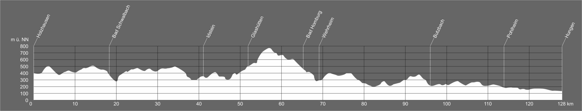
You need to be fit on this section, because it's uphill and downhill here. First you cross the Hessian state border. Then the tour leads through the Taunus with its clearly visible traces of forts, watchtowers, Limes ramparts and moats. Following the Limes closely in a north-easterly direction, the route leads to Saalburg Castle, the only fort on the Limes that has been almost completely rebuilt. Here you can take a detour to the spa town of Bad Homburg. Picturesque villages such as Butzbach line the rest of the route and invite you to take a break.
In the following, you will find this section divided into 3 daily stages. In addition to information on the route, you will also find GPS tracks to download and a selection of accommodation along the route for each stage.
In this section, the route is signposted throughout as the German Limes Cycle Path.


Leave Holzhausen an der Haide via the Bäderstraße. Drive past Reutig. Behind Reutig is the border between Rhineland-Palatinate and Hesse.
In Hesse, first drive via Martenroth to Grebenroth. Leave Grebenroth at Dellweg and continue through the forest to Heidenrod. There, take Rudolf-Dietz-Straße, Hüttenbachstraße, Krailing, Am Heiligenborn and Teichweg in the direction of Stegerhof.
From here, the route continues to Huppert. In Huppert, follow the Napoleonstraße and then the L3455 out of town in the direction of Kemel. Before you reach this village, however, you turn into the forest. Through the forest you reach the outskirts of Kemel. After a short stretch, the German Limes Cycle Route continues along Kemelerstrasse or Galgenstrasse, first past fields and then through a wood to Lindscheid (Bad Schwalbach).
Next, the route then leads to Adolfseck and then continues past Born somewhat off the beaten track. Then first to Watzhahn and on to Orlen. Just outside Orlen you then reach the Zugmantel fort. From here, the route continues past Eschenhahn and finally, after a longer drive, to Idstein. Outside the town of Idstein is then the Idstein-Dasbach Limes Tower.
The entire route of the German Limes Cycle Path available for download in all common file formats:
For a better overview, the route is also available divided into four sections. This allows you to plan your next trip or excursion to the unique UNESCO World Heritage Site Limes in the best possible way.
Our accommodation directory:
For a better overview, you can sort the accommodation alphabetically or by location along the Limes.


From the Idstein-Dasbach Limes Tower, first cycle through Dasbach. Then the German Limes Cycle Route continues through the forest to Alteburg Market. Not far from there was the Alteburg-Heftrich fort in Roman times.
The route then continues past fields and through a wood to Schloßborn. In Schloßborn, continue along Kröfteler Straße to the Glaskopf hikers' car park. From there the route continues to Glashütten.
Via Limburger Straße you reach Dornsweg and leave Glashütten in the direction of the forest. From here, the German Limes Cycle Route leads for a long distance through forests and does not pass through any villages. The route roughly follows the course of the Upper Germanic-Raetian Limes UNESCO World Heritage Site and repeatedly passes guard posts and fort sites.
At the Feldberg hikers' car park, continue in the direction of Sandplacken and from there to the Saalburg Roman fort (Bad Homburg v.d.H.). An impressive reconstruction of a Roman fort awaits you at the Saalburg. The fort also serves as a museum.
Through a wooded area you then reach the Saalburg settlement (Wehrheim). Leave the settlement at the Limesstraße and follow the path through the woods to the Roman tower 4/16 "Auf dem Gaulskopf". The route then continues through the forest to Ziegenberg Castle. Via Wiesental and Fauerbach v.d. Höhe you then reach Hoch-Weisel.
You then leave the village in Hausener Straße. The route then leads to the Hunnenkirchhof small fort. The route then continues to Hausen and from there to the Butzbach forester's lodge. From there, the route continues to Butzbach. Important finds from the cohort fort and the associated civilian settlement can be seen in the museum of the town of Butzbach (Roman section in the vaulted cellar).
The entire route of the German Limes Cycle Path available for download in all common file formats:
For a better overview, the route is also available divided into four sections. This allows you to plan your next trip or excursion to the unique UNESCO World Heritage Site Limes in the best possible way.
Our accommodation directory:
For a better overview, you can sort the accommodation alphabetically or by location along the Limes.


Leave Butzbach parallel to the B3 and follow until you reach Pohl-Göns. Then turn right here towards the forest. First drive along the forest and then enter the forest. In the forest you will pass fort "Dicker Wald 1" and tower site 4/40.
From the fort, continue in the direction of Langgöns. At the valley bridge, do not enter the town, but continue in the opposite direction to the Holzheimer Unterwald fort. From there, follow the course of the Limes in a straight line to the Limes watchtower at Pohlheim.
From here, roughly follow the course of the Limes for a short distance. Several times the cycle path briefly leads away from the Limes. Near Garbenteich, a short distance before the motorway, then turn sharply towards Grüningen.
Then leave Grüningen via Nollstraße and continue to Dorf-Güll. From here, first continue to Arnsberg monastery and then via Muschenheim to Bettenhausen. Initially keep in the direction of Lich-Langsdorf, but at the entrance to the town then continue in the direction of Hungen parallel to the road. You will then reach the centre of Hungen via Gießener Straße.
The entire route of the German Limes Cycle Path available for download in all common file formats:
For a better overview, the route is also available divided into four sections. This allows you to plan your next trip or excursion to the unique UNESCO World Heritage Site Limes in the best possible way.
Our accommodation directory:
For a better overview, you can sort the accommodation alphabetically or by location along the Limes.
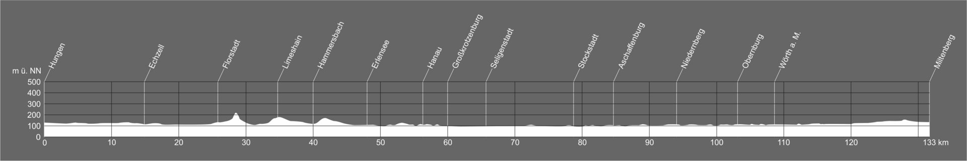
The route heads south through the charming natural landscape of the Wetterau. Here you pass idyllic small towns such as Echzell or Rückingen with archaeological evidence of the Roman past. After Rückingen, it is worth making a detour to Hanau. From Großkrotzenburg, the route runs along the Main River, where there are hardly any ascents until Miltenberg. Along the way, the towns of Seligenstadt, Stockstadt, Aschaffenburg, Niedernberg and Obernburg invite you to linger.
In the following, you will find this section divided into 3 daily stages. In addition to information on the route, you will also find GPS tracks to download and a selection of accommodation along the route for each stage.
In this section, the route is signposted throughout as the German Limes Cycle Path.


Leave Hungen in the direction of Inheiden. First continue to the Trais-Horloffer lake and then along the lake to the Hungen-Trais-Horloff station. From there you continue first in the direction of Steinheim and then Unter-Widdersheim.
Passing between Oberer and Unterer Knappsee, you then reach Utphe. The German Limes Cycle Route continues between fields to Berstadt and then to Echzell. The local history museum exhibits some finds from the Echzell fort. A metre-high "Jupiter Column" has been erected in the front garden.
Echzell is then left via the street Im Preulen. Via Landgrafenweg you reach Bingenheim. From there, the route leads first to Reichelsheim and then past the village of Leidhecken to Staden (Florstadt).
The German Limes Cycle Route then continues via the Roman road to Stammheim. Continue along Schloßstraße, along fields and through a forest to Altenstadt. Leave Altenstadt near the railway station in the direction of Oberau.
In Oberau, first follow Kochstraße and then along the edge of the village, past the Roman orchard to the "Roman statue and Limes tower". From here, continue in the direction of Limeshain to the small fort "Auf dem Buchkopf".
Continue to follow the course of the Limes. On this section you will pass several guard posts. At the "Limes signpost". The cycle path continues to Marköbel (Hammersbach). In Marköbel you can visit the remains of a fort and a thermal bath.
You leave Marköbel again via Hüttengesäßer Straße and continue between fields and forests to Ravolzhausen. You leave Ravolzhausen via Taunusstraße. A short distance later you finally reach Erlensee.
The entire route of the German Limes Cycle Path available for download in all common file formats:
For a better overview, the route is also available divided into four sections. This allows you to plan your next trip or excursion to the unique UNESCO World Heritage Site Limes in the best possible way.
Our accommodation directory:
For a better overview, you can sort the accommodation alphabetically or by location along the Limes.


In Erlensee, first follow John-F-Kennedy-Straße and then the cycle path along Siemensstraße. At the Roman playground you finally leave Erlensee. From Erlensee, the German Limes Cycle Path continues towards Hanau.
Through a forest you first reach the motorway, which can be crossed over a bridge. From there, the route continues past the St. Wolfgang monastery ruins. Shortly before Hanau, you will find the former Roman fort of Neuwirtshaus. From there, the trail leads through the forest to the outskirts of Hanau and then continues past several guard posts to Großkrotzenburg.
On the outskirts of Großkrotzenburg, you first reach the railway station, where you cross the railway line. Then follow Bahnhofstraße to Kirchstraße. Here you can still see some remains of the cohort fort. There is also a Roman section in the local history museum.
Via Tränengasse you reach the bank of the Main. Follow the bank to the Krotzenburg barrage. There you cross the Main. On the other side of the river, the route then follows the Main along the bank in the direction of Seligenstadt.
From Seligenstadt, the route continues along the banks of the Main, first to Mainflingen. After passing Mainflingen, the route then passes under the Mainflingen bridge to the Schwalbennest forest edge settlement.
At the edge of the settlement, you then leave Hesse and enter Bavaria. In Bavaria, too, the German Limes Cycle Route first follows the course of the Main River to Stockstadt. There is a Roman section in the Stockstadt museum of local history.
In Stockstadt you then change banks of the Main over the Stockstadt railway bridge. On the other side of the Main you continue to follow the Main. Passing Mainaschaff, you finally reach Aschaffenburg.
In Aschaffenburg there is a lot to see for all those interested in the Limes and the Romans. The collections in the Abbey Museum and the cork model collection in Johannisburg Castle are among the most important sights, together with the Pompejanum and the fort baths at Nilkheimer Park.
The entire route of the German Limes Cycle Path available for download in all common file formats:
For a better overview, the route is also available divided into four sections. This allows you to plan your next trip or excursion to the unique UNESCO World Heritage Site Limes in the best possible way.
Our accommodation directory:
For a better overview, you can sort the accommodation alphabetically or by location along the Limes.


In Aschaffenburg, ride over the Willigisbrücke bridge and cross the Main. Now the German Limes Cycle Path follows the Main on the other bank in the direction of Niedernberg.
You cross Niedernberg parallel to the Main and leave the municipality via Großwallstädter Straße. The route continues south along the river. Großwallstadt is also crossed close to the Main. You leave Großwallstadt via Mainstraße and continue to Obernburg.
In Obernburg, it is worth visiting the Obernburg Roman Museum on the Main Limes. There you can discover unique ancient finds. The museum offers interesting and informative exhibits for all age groups.
The German Limes Cycle Route then leads south along the Main to Wörth am Main. The Wörth fort was located on the outskirts of the present-day town. The fort was spared from overbuilding and lies relatively undisturbed underground to this day. In Wörth am Main itself, it is worth visiting the Roman section of the Maritime and Shipbuilding Museum.
From Wörth am Main, the German Limes Cycle Route continues along the Main first to Trennfurt, Laudenbach, then to Kleinheubach. In Kleinheubach, the route first leads along the main road to the fire station and then continues along Im Steiner. Via Altstadtweg you finally reach Miltenberg.
On the way from Kleinheubach to Miltenberg, you pass the cohort fort Altstadt, of which remains of the walls are still visible today. In the Museum Stadt Miltenberg, the Roman section deals with the history of the Roman presence in what is now Miltenberg. The museum is a little off the German Limes Cycle Route, but is of course worth a diversion.
The entire route of the German Limes Cycle Path available for download in all common file formats:
For a better overview, the route is also available divided into four sections. This allows you to plan your next trip or excursion to the unique UNESCO World Heritage Site Limes in the best possible way.
Our accommodation directory:
For a better overview, you can sort the accommodation alphabetically or by location along the Limes.
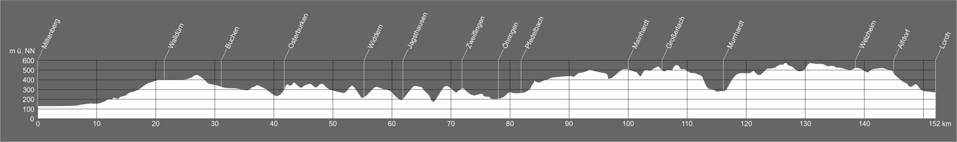
Shortly after Miltenberg, the cycle path leaves the Main and leads steadily uphill to Walldürn. From there it continues through the Odenwald along the Limes to Osterburken. The cycle path follows the traces of the Upper Germanic Limes through the Hohenlohe Plain, the Swabian-Franconian Forest Nature Park and passes towns such as Öhringen, Murrhardt or Welzheim with their rich historical heritage. The Upper Germanic and Raetian Limes meet in Lorch.
Below you will find this section divided into 4 daily stages. For each stage, you will find information on the route, GPS tracks for download and a selection of accommodation along the way.
In this section, the route is signposted throughout as the German Limes Cycle Path.


In the Miltenberg-West industrial estate, leave Miltenberg in the direction of Breitendiel. Via Weilbach, Amorbach, Schneeberg and the border between Bavaria and Baden-Württemberg, you reach Rippberg. Through a wooded area you then reach Walldürn.
In Walldürn, you first pass the cemetery and head towards the centre. At Würzburger Straße, leave Walldürn via the L518. After the bridge over the B27, turn into Alte Altheimer Straße. Passing fields and forests, you reach the Hettingen forester's lodge. The Hönehaus small fort is also located there.
The German Limes Cycle Route then continues from there to Rinschheim (Buchen) and Götzingen to Bofsheim. After a long stretch through forests, you finally arrive in Osterburken. First you follow the Sportplatzweg here and then head for the railway station.
In addition to a Roman museum, the foundation walls of a guard post and parts of a double fort can also be discovered in Osterburken.
The entire route of the German Limes Cycle Path available for download in all common file formats:
For a better overview, the route is also available divided into four sections. This allows you to plan your next trip or excursion to the unique UNESCO World Heritage Site Limes in the best possible way.
Our accommodation directory:
For a better overview, you can sort the accommodation alphabetically or by location along the Limes.


Near the Limes tower you leave the town of Osterburken. From there, continue to the Limes car park Marienhöhe. Via Wemmershof, Hergenstadt, through the forest to Hopfengarten and past agricultural land you reach Liebenstadt. The German Limes Cycle Path leads under the A81 to Unterkessach (Widdern). Passing fields and forests, you then reach Jagsthausen via the Leuterstalerstraße.
In Jagsthausen, in addition to a museum with a Roman section, the open-air museum Römerbad is also worth a visit. You leave Jagsthausen again via Bergstraße. The route then continues in a very rural manner via Edelmannshof and Sindringen.
After crossing the L1045 and the Kocher, you continue towards Schießhof through the forest to Pfahlbach (Zweiflingen). Passing the Limes view at Pfahldöbel, you first reach Westernbach and finally Öhringen. Head towards the railway station to reach the town centre.
In the Weygang Museum you will find precious finds from Roman times. Öhringen also has a sculpture park with replicas of Roman finds, a Roman fountain and many other interesting sights for all travellers along the Limes.
The entire route of the German Limes Cycle Path available for download in all common file formats:
For a better overview, the route is also available divided into four sections. This allows you to plan your next trip or excursion to the unique UNESCO World Heritage Site Limes in the best possible way.
Our accommodation directory:
For a better overview, you can sort the accommodation alphabetically or by location along the Limes.
© Gemeinde Pfedelbach")


Leave Öhringen in the district of Cappel. You will first pass the LimesBlick Öhringen. Then continue in the direction of Pfedelbach. Along the outskirts of Pfedelbach, the route continues in the direction of Heuberg. You will then reach Gleichen via Buchhorn.
In Gleichen you have the option of taking a diversion to LimesBlick Pfedelbach. The Limes cycle path then continues past Gleichen Lake to Frohnfalls. Along the L1050, the path leads in the direction of Geißelhardt. However, leave the L1050 before Geißelhardt and take Gailsbacher Straße and the Römergraben to watchtower 9/64. From there you first reach Gailsbach. Mainhardt is then reached via Mainhardter Straße and the L1050.
The museum in the former Catholic church in Mainhardt contains finds from the fort and civilian settlement with numerous explanations. You leave Mainhardt via Mönchsstraße and drive through the forest to Mönchsberg. Next, you reach the guard post 9/75 "Hofbergle" and continue towards Grab (Großerlach). At the cemetery, leave Grab in the direction of the Limes tower.
The Limes tower at Grab was reconstructed on the basis of archaeological findings. The rampart and ditch have also been reconstructed and a path cut through the forest. From the car park, the Limes cycle path runs through Morbach, Marbächle, Mannenweiler, Steinberg, Fritzhof, Spechtshof.
From Spechtshof, the route continues to watchtower 9/91, the "Römerschanze", through the forest. First you then reach Siegelsberg and then arrive in the centre of Murrhardt at the end of the stage.
Around Murrhardt you will find several guard posts. In the town itself, the Carl Schweizer Museum offers a Roman collection of finds from forts, civilian settlements and from the Limes.
The entire route of the German Limes Cycle Path available for download in all common file formats:
For a better overview, the route is also available divided into four sections. This allows you to plan your next trip or excursion to the unique UNESCO World Heritage Site Limes in the best possible way.
Our accommodation directory:
For a better overview, you can sort the accommodation alphabetically or by location along the Limes.


Leave Murrhardt via Obermühlenweg in the direction of Köchersberg. Passing tower 9/194, you first come to Käsbach, then Vorderwestermurr and Fautspach. On the outskirts of Sechselberg, you pass the hikers' car park and continue towards Ebnisee.
There was a small fort at Ebnisee in Roman times. Via Gausmannsweiler, Eckartsweiler and Seiboldsweiler you then reach Welzheim. Shortly before Welzheim you will find the Rötelsee small fort. In the centre of Welzheim you will find the Welzheim Museum with a large Roman section. You leave Welzheim again at the eastern fort.
First, the German Limes Cycle Route leads in the direction of Rienharz. Before reaching the village, however, the path turns off via Hagmühle to Haghof. Here you follow the course of the Limes to Pfahlbronn (Alfdorf). The trail then continues along the Limes through the forest to Lorch. On the way, you will pass several guard posts. Out of the forest you reach Lorch near the monastery. There you will also find a reconstructed Limes watchtower. You then reach the centre of Lorch via Klosterstraße.
The entire route of the German Limes Cycle Path available for download in all common file formats:
For a better overview, the route is also available divided into four sections. This allows you to plan your next trip or excursion to the unique UNESCO World Heritage Site Limes in the best possible way.
Our accommodation directory:
For a better overview, you can sort the accommodation alphabetically or by location along the Limes.
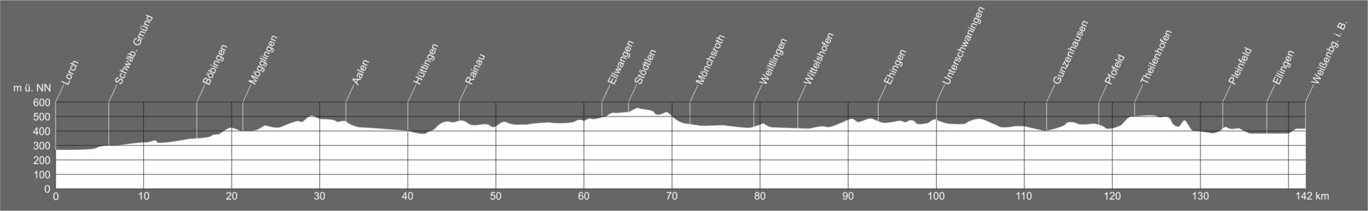
From Lorch, the route is somewhat flatter through the Rems Valley to the Staufer town of Schwäbisch Gmünd and on to Aalen. On the way across the Ostalb, the cycle path passes the Roman excavations in Rainau. At Mönchsroth, the cycle path crosses the Bavarian border and leads via Wittelshofen and Ehingen to Gunzenhausen. From here it is another 30 kilometres through the Franconian Lake District to the Roman town of Weißenburg i. Bay.
Below you will find this section divided into 3 daily stages. For each stage you will find information about the route, GPS tracks for download and a selection of accommodation along the route.
In this section, the path is signposted throughout as the German Limes Cycle Path.


Leave Lorch via Hohenstaufenstraße and cycle parallel to the B29 in the direction of Schwäbisch Gmünd. The German Limes Cycle Route continues not far from the Freimühle fort (the Schirenhof fort can also be found a little off the route). The border between the provinces of Upper Germania and Raetia also lies near Schwäbisch Gmünd. The place where the Upper Germanic Limes met the Raetian Limes is marked today with a reconstruction.
Via the Hirschbrunnenweg you then reach the centre of Schwäbisch Gmünd. There, the museum in the Prediger with its Roman section invites you to visit. The route leads through the city centre and then along the river Rems to Hussenhofen, Zimmern and Böbingen.
In Böbingen, you will pass near the Unterböbingen fort. Now the route leads first to Mögglingen and then via Hermannsfeld and Essingen to Aalen. First you pass the industrial area in Aalen and then come to the city centre. In Aalen, the Limes Museum, built directly on the site of a Roman fort, offers an insight into military and civil life in the Roman provinces.
Aalen is then left in the direction of Wasseralfingen. From there, the route continues along the Kocher river to Hüttlingen and finally to Rainau.
The entire route of the German Limes Cycle Path available for download in all common file formats:
For a better overview, the route is also available divided into four sections. This allows you to plan your next trip or excursion to the unique UNESCO World Heritage Site Limes in the best possible way.
Our accommodation directory:
For a better overview, you can sort the accommodation alphabetically or by location along the Limes.


From Rainau, the German Limes Cycle Route first leads to the "Bucher Stausee" reservoir. There you will find a tower reconstruction, a fort and the fort vicus to visit. Continuing towards Schwabsberg, you then turn off in the direction of the Limes Gate. The Limes Gate is a unique structure on the Upper Roman-Raetian Limes and has been converted into a museum.
From the Dalkingen Limes Gate, the route continues to Dalkingen, Haisterhofen, Röhlingen and Pfahlheim. The Limes Cycle Route continues first to Halheim (Ellwangen) past Fort Halheim to Gerau (Stödtlen). Stillau, Dambach, Strambach and on across the Baden-Württemberg - Bavaria border to Mönchsroth.
A little off the route of the Limes Cycle Path you will find the Limes Tower Mönchsroth. The route continues via Wilburgstetten, Welchenholz, along the Wörnitz, to Neumühle and then past the market town of Weiltlingen. First you come to the Ruffenhofen fort and LIMESEUM. A visit to the museum and the fort grounds is a must for anyone interested in the Limes. The trail continues past the LIMESEUM and finally reaches Wittelshofen.
The entire route of the German Limes Cycle Path available for download in all common file formats:
For a better overview, the route is also available divided into four sections. This allows you to plan your next trip or excursion to the unique UNESCO World Heritage Site Limes in the best possible way.
Our accommodation directory:
For a better overview, you can sort the accommodation alphabetically or by location along the Limes.


From Wittelshofen, the German Limes Cycle Route leads to Ehingen. On the way there, you pass through farmland at Untermichelbach, Dühren and Grüb.
Pass through Ehingen in the direction of Dambach. A fort with an amphitheatre has been found near Moosgraben. Continue through the forest to the St2221. From here, follow the road in the direction of Dennenlohe. Shortly before you reach Dennenlohe, turn off towards Dennenloher See. After going halfway around the lake, the Limes cycle path continues towards Großlellenfeld. Before Großlellenfeld, turn off towards Kleinlellenfeld.
From here, the cycle path follows the course of the Upper Germanic-Raetian Limes. First you cross Unterhambach and continue through forests and past fields to Gunzenhausen. In Gunzenhausen it is worth visiting the archaeological museum. A short diversions also takes you to Schloßbuck, where you will also find a small fort with a memorial stone and the remains of guard post 14/6.
Take the Gundelsheimer Weg and leave Gunzenhausen in the direction of Pfofeld and then Theilenhofen. You will pass the fort baths at Theilenhofen. From there, the route first leads to Thannhausen, past watchtower 14/20, Dorsbrunn, Walkerszell and Gündersbach (Pleinfeld).
The route then continues to Ellingen past Fort Gündersbach. The Sabloneturm fort is located in Ellingen. You leave Ellingen via the Weißenburger Straße and finally arrive in Weißenburg.
With the Biriciana fort, the Roman thermal baths as a museum and the Roman Museum, Weißenburg offers a variety of attractions for travellers along the Limes.
The entire route of the German Limes Cycle Path available for download in all common file formats:
For a better overview, the route is also available divided into four sections. This allows you to plan your next trip or excursion to the unique UNESCO World Heritage Site Limes in the best possible way.
Our accommodation directory:
For a better overview, you can sort the accommodation alphabetically or by location along the Limes.
This section of the route begins again with some hilly passages. Close to the Limes, the route leads to Kipfenberg and through the Altmühltal Nature Park. Shortly before Kelheim, the Limes Cycle Path meets the Danube. From here it follows the Danube Cycle Path and continues to Regensburg.
Below you will find this section divided into 3 daily stages. For each stage you will find information about the route, GPS tracks for download and a selection of accommodation along the route.
In this section, the path is signposted at first as the German Limes Cycle Path. From Kehlheim onwards the route is signposted as "Danube Cycle Path"


You start in Weißenburg near the Ellinger Tor. The town is then left via Niederhofener Straße in the direction of Niederhofen. The Limes cycle path continues to Oberhochstatt. Along fields and forests, the stage first leads to Burgus Burgsalach. The Burgus is considered a unique Limes structure, parallels to which are only known from North Africa.
At the starting point of the Burgsalach Roman Experience Trail, the route turns off at a right angle. You pass the preserved guard post 14/48. Shortly before you reach Raitenbuch Fort, the German Limes Cycle Route turns off in the direction of Raitenbuch. The route then passes the St. Leonhard Chapel. The route continues first in the direction of Peterbuch, then you reach Erkertshofen.
Before leaving Erkertshofen, you come to a tower replica and a Roman playground. From there, the trail leads through the forest to Hirnstetten, on to Pfahl, past Böhming and finally to Kipfenberg.
In addition to the reconstructed wooden Limes guard post 14/78 and the Böhming fort, the Roman and Bavarian Museum in Kipfenberg is particularly worth a visit.
The entire route of the German Limes Cycle Path available for download in all common file formats:
For a better overview, the route is also available divided into four sections. This allows you to plan your next trip or excursion to the unique UNESCO World Heritage Site Limes in the best possible way.
Our accommodation directory:
For a better overview, you can sort the accommodation alphabetically or by location along the Limes.


In Kipfenberg you first take the ascent to Kipfenberg Castle. There you will find the Roman and Bavarian Museum. The Römer- und Bajuwaren Museum Burg Kipfenberg with Infopoint Limes shows the life of the Romans in the province of Raetia, the construction and fall of the Limes and the grave of a rich Germanic who had served as a soldier in the late Roman army.
The German Limes Cycle Route then continues not far from the course of the Upper Germanic-Raetian Limes past several guard posts and the geographical centre of Bavaria. The cycle path now repeatedly crosses the course of the Limes and then leads to Denkendorf. Not far from watchtower 15/7 there is an information point on the Limes and a reconstructed piece of palisade.
You leave Denkendorf again in the district of Zandt. Follow the fields north of the Limes line in the direction of Breitenhill, Megmannsdorf. In the district of Schamhaupten you reach Altmannstein. The German Limes Cycle Route leads through the districts of Sandersdorf, Neuenhinzenhausen and Sellern to Altmannstein itself.
The rural route then continues towards Hagenhill and Laimerstadt to Hienheim. You cross the Danube with the Eining/Hienheim ferry. Once on the other bank, the route leads past the cohort fort Abusina Eining to Sittling. From there you finally arrive at the outskirts of Bad Gögging.
In Bad Gögging, spa and bathing culture is very prominent. There you will not only find a thermal spa that invites you to relax from the exertions of the Limes Cycle Route, but you can also visit the remains of the oldest Roman spa in Bavaria in the Roman Museum for Spa and Bathing.
The entire route of the German Limes Cycle Path available for download in all common file formats:
For a better overview, the route is also available divided into four sections. This allows you to plan your next trip or excursion to the unique UNESCO World Heritage Site Limes in the best possible way.
Our accommodation directory:
For a better overview, you can sort the accommodation alphabetically or by location along the Limes.


This stage begins just outside Bad Gögging and first leads past fields in a north-easterly direction. The route then continues towards Staubing. From there the cycle path follows the course of the Danube.
Several Roman forts can be found in the area. At the late Roman fort of Weltenburg, the German Limes Cycle Route then crosses the Danube. There is no bridge here, however, but you can cross the river with the Stausacker Danube ferry. The cycle path then follows the river bank; the Weltenburg Monastery can be seen opposite.
The trail then leads between Hirschberg and Weltenburger Enge past the Liberation Hall and into Kehlheim. Cross the Ludwig-Danube-Main Canal and continue into the old town. Via the Kehlheim footbridge you cross the Main-Danube Canal. Follow the canal to the confluence with the Danube. From the Römerbruchstraße, the German Limes Cycle Route then follows the Danube Cycle Route. If the German Limes Cycle Route is not signposted separately, the Danube Cycle Route is signposted.
At Bad Abbach, the cycle path crosses the Danube and continues along the opposite bank. On this section, you cycle very rurally and pass through small villages again and again. Along the meandering Danube you finally arrive at the outskirts of Regensburg. The stage ends near the House of Bavarian History on the outskirts of Regensburg city centre.
Regensburg was the site of the only legionary camp in the province of Raetia. Parts of the surrounding wall are still visible in the city today. Of the massive gates with their flanking, defensive towers, parts of the north gate to the Danube, the Porta Praetoria, have been preserved. The largest permanent exhibition in Bavaria on the subject of the Romans with the "Stone Founding Document" can be found in the History Museum. The Roman Museum in the city's west (Archaeological Pavilion) houses what is probably the oldest Roman brewery north of the Alps.
The entire route of the German Limes Cycle Path available for download in all common file formats:
For a better overview, the route is also available divided into four sections. This allows you to plan your next trip or excursion to the unique UNESCO World Heritage Site Limes in the best possible way.
Our accommodation directory:
For a better overview, you can sort the accommodation alphabetically or by location along the Limes.
The last stage of the Limes Cycle Path begins in Regensburg, the site of the only legionary camp in the Roman province of Raetia. This section passes the towns of Straubing and Künzing with their impressive Roman finds without any major climbs and ends in the three-river city of Passau.
Below you will find this section divided into 3 daily stages. For each stage you will find information about the route, GPS tracks for download and a selection of accommodation along the route.
In this section, the path is signposted throughout as the "Danube Cycle Path".


In Regensburg, the Danube must first be crossed. (Via Eiserne Brücke - Grieser Steg, Protzenweilerbrücke).
The route continues over the Regenbrücke bridge over the Regen river and on through Regensburg to the outskirts. Past the Walhalla, the cycle path now follows the north bank of the Danube. The route leads along fields, small villages and hamlets. Again and again you leave the direct bank of the Danube before you get back to the Danube.
The route remains on the northern bank of the UNESCO World Heritage Danube Limes, i.e. you see the former border and the former Roman territories from the perspective of the "barbarians". At the Straubing lock, you then cross the Danube Limes again and continue on "Roman" territory. The cycle path then continues from there to the centre of Straubing.
The world-famous "Roman treasure find of Straubing" is exhibited in the Gäuboden Museum. There you can explore the long history of the town of Straubing, the Roman Sorviodurum.
The entire route of the German Limes Cycle Path available for download in all common file formats:
For a better overview, the route is also available divided into four sections. This allows you to plan your next trip or excursion to the unique UNESCO World Heritage Site Limes in the best possible way.
Our accommodation directory:
For a better overview, you can sort the accommodation alphabetically or by location along the Limes.


The German Limes Cycle Route crosses the Danube at the castle bridge in Straubing. The route continues along Chamer Straße and also crosses the Alte Donau.
On the north bank of the Danube, the route first passes agricultural areas and then continues through the town of Bogen. Afterwards, the German Limes Cycle Route continues parallel to the Danube. Here you will encounter several small villages and hamlets. In Roman times, the northern bank of the Danube was outside the Roman Empire and the Danube formed the Limes.
After passing through the town of Deggendorf, the German Limes Cycle Path continues parallel to the Danube again from the mouth of the Isar River. The cycle path then passes Niederalteich. At the village of Winzer, you cross the Danube again to the south bank. From here you are back in the "Roman Empire".
The cycle path continues through a rural area at some distance from the river until you finally arrive in Künzing. In Künzing, the Quintana Museum invites you to discover finds and findings from the Middle Imperial auxiliary fort of Künzing/Quintanis and the surrounding civilian settlement.
The entire route of the German Limes Cycle Path available for download in all common file formats:
For a better overview, the route is also available divided into four sections. This allows you to plan your next trip or excursion to the unique UNESCO World Heritage Site Limes in the best possible way.
Our accommodation directory:
For a better overview, you can sort the accommodation alphabetically or by location along the Limes.

 © Verein Deutsche Limes-Straße")
The last stage of the German Limes Cycle Route runs on the Danube Cycle Route from Künzing to the German-Austrian border in Passau. The route first follows the Danube along the south bank to Vilshofen an der Donau. There the cycle path then crosses the Marienbrücke bridge to the north bank.
In Roman times, this crossing to the north bank would have meant crossing from the Roman province of Raetia over the "Danube Limes" into the territory of the barbarians. Today, fortunately, the Danube no longer serves as a border at this point and you can simply continue along the north bank.
The trail now continues along the north bank, parallel to the Danube, to Passau. You cycle idyllically along the Danube past small woods and agricultural land. You have the opportunity to enjoy the Danube Limes UNESCO World Heritage Site and nature.
Once in Passau, the Danube is crossed again. Via the Kachlet lock on the Danube, you return to the "Roman Empire" in Raetia. The last kilometres of the German Limes Cycle Route then lead back along the Danube Cycle Route on the south bank to Passau's old town and finally end at the "Dreiflüsseeck" (Three Rivers Corner). In Roman times, there was a provincial border there.
In Passau, a visit to the Roman museum Kastell Boiotro is a must. It is located in a late-medieval craftsmen's house in Passau's Innstadt district. It rests on the foundations of the late Roman fort of Boiotro, which the Romans built around 280 AD. In 375, the fort was evacuated by the military and fell into disrepair. Remains of the fort wall and the watchtowers are visibly preserved in the open-air site and in the museum.
In the new conception carried out in 2014, the Boiotro fort is the most important exhibit. The Danube, as the northern border, separated the Roman Empire from Barbaricum, while the Inn formed a provincial and customs border. Digital media such as touch screens, a light installation and a virtual reconstruction illustrate Passau's complex Roman history with its 5 forts and surrounding civilian settlements.
The entire route of the German Limes Cycle Path available for download in all common file formats:
For a better overview, the route is also available divided into four sections. This allows you to plan your next trip or excursion to the unique UNESCO World Heritage Site Limes in the best possible way.
Our accommodation directory:
For a better overview, you can sort the accommodation alphabetically or by location along the Limes.
![[Translate to English:] Karte - Deutsche Limes-Radweg in Rheinland-Pfalz](/fileadmin/limesstrasse/images2019/radweg/Karte-RP.png "[Translate to English:] Karte - Deutsche Limes-Radweg in Rheinland-Pfalz")
From Bad Hönningen am Rhein to Nastätten
The first 75 kilometers of the Upper Germanic Limes pass through Rhineland-Palatinate. Beginning at the Rhine at Bad Hönningen and Rheinbrohl, it runs through the outer heights of the Westerwald to the mountain range of the Hintertaunus. Along this route, 132 watchtowers, 9 small forts and 9 cohort forts were located. As the Limes in Rhineland-Palatinate is mainly located in the forests of Westerwald and Taunus, the walls and ditches, the remnants of Roman watchtowers and the protection devices of some of the forts are still visible in many sections of the Limes. They are accessible via the Limes Hiking Trail. In the forest at the fort Holzhausen, for instance, one of the best preserved forts of all of the Limes can be seen. In addition, in Rhineland-Palatinate there are seven reconstructed watchtowers along the German Limes Road. The watchtowers were built between 1874 and 2004 according to the current state of research at the time of their construction. This is why the watchtowers differ from one another in regard to their appearance. The foundation walls of several forts and baths were preserved. At some places, the wooden palisade was reconstructed and the wall and ditch were renewed. At important stations along the hiking trails, information boards explain the Limes monument while the finds from the sites can be seen in the museums.
![[Translate to English:] Karte - Deutsche Limes-Radweg in Hessen](/fileadmin/limesstrasse/images2019/radweg/Karte-HE.png "[Translate to English:] Karte - Deutsche Limes-Radweg in Hessen")
From Heidenrod to Mainhausen
In Hesse, the section of the Limes recognized as a UNESCO World Heritage Site runs from Heidenrod at the watchtower 2/35 “Am Laufenselder Weg” to Mainhausen am Main.
The Limes proceeds across the wooded heights of the Taunus mountain range and, running in a big arch, comprises the fertile Wetterau area. The 18 big and 31 small forts as well as the more than 200 watchtower locations along the 153 km of the Hessian part of the Limes are in varying states of preservation, depending on the post-Roman use of the area: in the zones used for agriculture there are not many visible remains of the Limes while in the forests especially the walls and ditches can still be seen. It is in the forests as well that most of the forts and watchtowers can be identified in the shape of rising ground. The visible traces of the Limes as well as its preserved and restored architectural remains one comes across in the area, e.g. the forts of Feldburg and Kapersburg, bring Roman history back to life in the imagination of the visitor. The most extensive overview of the life of Roman soldiers and civilian population at the border of the Roman Empire is offered by the only almost completely re-erected fort at the Limes: the Saalburg in the Taunus mountain range close to Bad Homburg v. d. Höhe. At the beginning of the 20th century, this Roman fort was reconstructed on the initiative of Emperor Wilhelm II. During the last years, many new buildings were added and the fort was made an archaeological park.
![[Translate to English:] Karte - Deutsche Limes-Radweg in Baden-Württemberg](/fileadmin/limesstrasse/images2019/radweg/Karte-BW.png "[Translate to English:] Karte - Deutsche Limes-Radweg in Baden-Württemberg")
From Walldürn to Halheim
The 164-km-long-Baden-Württemberg section of the Limes recognized as a UNESCO World Heritage Site dates back to the rule of the Roman emperors Antoninus Pius (138-161 AD) and Marcus Aurelius (161-180 AD). Traces of the ancient border system can be found in scenic places of varying nature, as the Odenwald, the Hohenlohe plain, the Swabian-Franconian Forest and the Alb foreland. 30 towns and boroughs in six dis-tricts (Neckar-Odenwald-Kreis, Landkreis Heilbronn, Hohenlohekreis, Landkreis Schwäbisch Hall, Rems-Murr-Kreis and Ostalbkreis) are situated along this world-renowned monument.
340 watchtowers as well as 16 big and 17 small forts are known in addition to the proper borders. The Baden Württemberg Limes belongs partly to the Upper Germanic Limes (101 km) and partly to the Rhaetian Limes (63 km).The border between the provinces Germania Superior (“Upper Germania”) and Rhaetia met with the Limes in the Rotenbach valley between the towns of Lorch and Schwäbisch Gmünd (in the Ostalbkreis district). Numerous museums and reconstructions transport a vivacious image of the ancient border system.
There is an older Roman boundary more to the West and South which is not part of the UNESCO World Heritage. It runs from the river Main through the Odenwald mountain range to the banks of the river Neckar (this part is called the “Odenwaldlimes”), after-wards alongside of the river Neckar to the borough of Köngen (the so-called “Neckarlimes”) and, finally, across the Swabian Jura mountain range to the Nördlinger Ries landscape (the so-called “Alblimes”). Due to its many visible remains, this boundary is widely known as well and the destination of many antiquity enthusiasts.
In addition to the numerous Roman attractions, highlights in the landscape are lined up side by side along the 208-kilometer route in Baden-Württemberg. The route through Baden-Württemberg leads over mountain ranges and plateaus, crosses the deep valleys of the twin rivers Jagst and Kocher and leads through the Rems Valley and the Kocher Valley. Demanding routes - e.g. from Pfedelbach to Welzheim - alternate with more flat sections, for instance between Lorch and Schwäbisch Gmünd.
![[Translate to English:] Karte - Deutsche Limes-Radweg in Bayern](/fileadmin/limesstrasse/images2019/radweg/Karte-BY.png "[Translate to English:] Karte - Deutsche Limes-Radweg in Bayern")
From Mönchsroth to Passau
The Upper Germanic-Rhaetian Limes is Bavaria’s best-known archaeological monument. It symbolizes Roman antiquity from the 1st to the 3rd century AD. Beginning at the Württemberg-Bavarian border, the Rhaetian Limes crosses the territories of Middle Franconia and Upper Bavaria, ending at the banks of the river Danube in the territory of Lower Bavaria.
As in the other federal states, the Limes has been the subject of systematical academic research conducted by the Reichs-Limeskommission (Imperial Limes Commission) from 1892 on. Prior to that, the Latin written sources concerning the Limes had been interpreted by Johann Turmair, known as Aventinus (1477-1534). The meaning of the Rhaetian Limes as a wall or a palisade and its connection to the Devil’s Wall was already recognized by clergyman Christoph Wägemann (1666-1713) of Oberasbach. The first map of the “Devil’s Wall” was made by headmaster Johann Alexander Döderlein (1675-1745) of Weißenburg.
The 117 km of the Rhaetian Limes in Bavaria and its hinterland were secured by around 180 watchtowers. Subsequently, ten small forts were built to guard key locations like roads, rivers and steep valleys. Behind the Limes, there were 17 major military bases. The linear elements and the watchtower locations as well as some of the forts of this ancient system of border control have been largely preserved and are still visible today. At other points, where the Limes is not visible anymore, the ancient border is marked by reconstructions and memorial stones, set up on the initiative of the Bavarian king Maximilian II. from 1861 on.
Shortly before Kelheim, the Limes cycle path meets the Danube. From here it follows the Danube cycle path and continues to Passau. The only legionary camp in the province of Raetia is located in the area of today's old town of Regensburg. It was built at the end of the 2nd century AD. built and is directly related to the Marcomannic Wars.
Follow the signs of the Rhine Cycle Route EuroVelo 15 between Bad Hönningen and Remagen and discover the Lower Germanic Limes in Rhineland-Palatinate.
![[Translate to English:] Höhenpfofil - Deutsche Limes-Radweg in Rheinland-Pfalz](/fileadmin/limesstrasse/images2019/radweg/Profil-RP.png "[Translate to English:] Höhenpfofil - Deutsche Limes-Radweg in Rheinland-Pfalz")
![[Translate to English:] Höhenpfofil - Deutsche Limes-Radweg in Hessen](/fileadmin/limesstrasse/images2019/radweg/Profil-HE.png "[Translate to English:] Höhenpfofil - Deutsche Limes-Radweg in Hessen")
![[Translate to English:] Höhenpfofil - Deutsche Limes-Radweg in Baden-Württemberg](/fileadmin/limesstrasse/images2019/radweg/Profil-BW.png "[Translate to English:] Höhenpfofil - Deutsche Limes-Radweg in Baden-Württemberg")
![[Translate to English:] Höhenpfofil - Deutsche Limes-Radweg in Bayern](/fileadmin/limesstrasse/images2019/radweg/Profil-BY.png "[Translate to English:] Höhenpfofil - Deutsche Limes-Radweg in Bayern")